Difference between revisions of "Kentish Flats Wind Farm - 6th February 2010"
m |
(route added) |
||
| Line 1: | Line 1: | ||
| − | [[Image:Kentish_Flats_185488397_729bb056f4_o.jpg|left| | + | [[Image:Kentish_Flats_185488397_729bb056f4_o.jpg|left|200px]] |
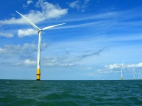
5 miles North of Herne Bay lie 30 wind turbines 115 metres tall arranged in a square of North Sea 1.5 miles across. | 5 miles North of Herne Bay lie 30 wind turbines 115 metres tall arranged in a square of North Sea 1.5 miles across. | ||
| Line 14: | Line 14: | ||
Anyone interested please sign up [http://www.towerhamletscanoeclub.co.uk/forum/viewtopic.php?f=35&t=278&sid=c8c84212c827fa93c71e00197edab533 here] and book boats [http://www.towerhamletscanoeclub.co.uk/wiki/Equipment_booking_form here] | Anyone interested please sign up [http://www.towerhamletscanoeclub.co.uk/forum/viewtopic.php?f=35&t=278&sid=c8c84212c827fa93c71e00197edab533 here] and book boats [http://www.towerhamletscanoeclub.co.uk/wiki/Equipment_booking_form here] | ||
| − | [[Image:Maunsell_Army_Fort.jpg|left|400px]] | + | [[Image:Maunsell_Army_Fort.jpg|left|200px]] |
| + | |||
| + | |||
| + | |||
| + | |||
| + | |||
| + | |||
| + | |||
| + | |||
| + | |||
| + | |||
| + | |||
| + | |||
| + | |||
| + | |||
| + | |||
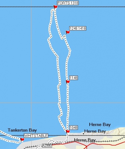
| + | Here's the route we took. The right hand track is the route out and the left hand track is the route back. The '1248 1418' flag marks the northern edge of the wind farm, the southern edge is where we change course to head South on the way home. | ||
| + | You can see how far we drifted West in our short breaks and also how steering 130 degrees (more like E than S) was needed to get us to go more or less South. Our straightest steady course is the section to the forts. Amazing what the sight of a supertanker bearing down on you will do. | ||
| + | |||
| + | [[Image:ShiveringSands.jpg|left|400px]] | ||
Revision as of 16:30, 7 February 2010
5 miles North of Herne Bay lie 30 wind turbines 115 metres tall arranged in a square of North Sea 1.5 miles across. We could go there on 6th February 2010. http://www.kentishflats.co.uk
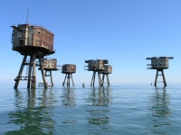
And if we get good weather and feel up to it then two miles further out are the 7 deserted WW2 forts of Shivering Sands. Shivering Sands Forts
Good photo here Shipping Channel
This would be a trip for 3 star sea paddlers with experience of paddling distances of up to 20 miles. We might have to paddle that far without the chance to get out of the boat. The forts are 7.5 miles from the nearest land (i.e. 2.5 hours away) and to get to them we have to cross a shipping lane.
Anyone interested please sign up here and book boats here
Here's the route we took. The right hand track is the route out and the left hand track is the route back. The '1248 1418' flag marks the northern edge of the wind farm, the southern edge is where we change course to head South on the way home. You can see how far we drifted West in our short breaks and also how steering 130 degrees (more like E than S) was needed to get us to go more or less South. Our straightest steady course is the section to the forts. Amazing what the sight of a supertanker bearing down on you will do.


